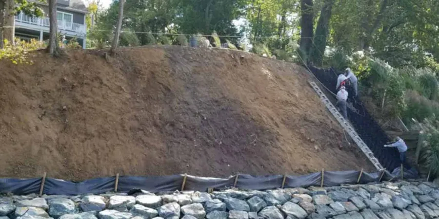
Anchorage sits on a mix of glacial till, alluvial deposits, and discontinuous permafrost, a combination that makes surface erosion a persistent challenge for any earthwork. The seasonal freeze-thaw cycle loosens the upper soil mantle, and spring snowmelt can carry away fine particles at rates that surprise newcomers. We have seen cut slopes lose a foot of material in a single wet May. That is why we start every soil erosion analysis by mapping the active layer depth and the drainage network across your parcel. Understanding how water moves through the site is the first step toward keeping soil where it belongs, and it often requires pairing surface observations with a subsurface check through a georadar survey to locate buried ice or perched water tables before grading begins.
A single spring melt can remove a foot of topsoil from an unprotected cut slope in Anchorage if the active layer is saturated.
Scope of work
Area-specific notes
In Anchorage, we often see erosion problems start at the toe of a slope where the seasonal ice lens melts and leaves a void. The overlying soil then collapses, and a small rill becomes a gully within a single summer. That is why our analysis always includes a freeze-thaw vulnerability index based on the number of annual freeze cycles at your specific elevation. If the index is high, we recommend immediate surface armoring or an engineered drainage blanket. Ignoring this local behavior can turn a minor grading job into a costly slope failure that affects adjacent properties. The risk is real, and it is completely avoidable with a proper erosion assessment before mobilization.
Standards used
ASTM D422 – Particle-size analysis of soils, ASTM D2488 – Description and identification of soils (visual-manual procedure), RUSLE2 – Revised Universal Soil Loss Equation (USDA-ARS)
Linked services
Surface Erosion Risk Assessment
Field mapping of rills, gullies, and sheet erosion zones combined with RUSLE2 modeling. We measure slope geometry, soil texture, and vegetative cover, then deliver a risk map that identifies areas needing immediate stabilization. Typical turnaround is 5 business days.
Subsurface Erosion & Internal Piping Study
For sites underlain by silty glacial till or stratified alluvium, we evaluate internal erosion potential using pinhole dispersion tests (ASTM D4647) and filter criteria analysis. This service is critical for dam embankments, levees, and deep excavations in the Anchorage Bowl.
This service complements our laboratory testing work for a complete project analysis.
Typical parameters
Q&A
How much does a soil erosion analysis cost in Anchorage?
A standard soil erosion analysis for a residential or small commercial lot in Anchorage ranges between US$900 and US$2,760, depending on the parcel size, the number of field visits required, and whether you need a full RUSLE2 model or a simpler qualitative assessment. Larger subdivisions or projects with complex drainage will be at the upper end.
Do I need an erosion analysis before building on Hillside or near Potter Marsh?
Yes, especially on the Hillside where steep glacial till slopes and seasonal seeps are common. The Anchorage Municipal Code requires a Storm Water Pollution Prevention Plan (SWPPP) for any disturbance over one acre, and an erosion analysis is the technical backbone of that plan. Near Potter Marsh, the high water table and peat soils make erosion control even more critical to avoid sediment reaching the wetland.
What is the difference between surface erosion and internal piping?
Surface erosion is the visible removal of soil by rain, snowmelt, or wind across the ground surface. Internal piping, on the other hand, occurs when water flows through preferential pathways inside the soil mass, washing out fine particles and creating hidden voids. Both can undermine foundations, but piping is harder to detect without a targeted analysis using dispersion tests and filter criteria.
Can you run an erosion analysis during winter when the ground is frozen?
We can, but with limitations. Frozen ground limits our ability to take undisturbed samples and perform field infiltration tests. However, we can still map drainage patterns, review historical snowmelt data, and collect surface samples for lab analysis. We recommend scheduling the full field campaign after the active layer has thawed, typically by mid-May in Anchorage.