Anchorage sits on the Cook Inlet basin with deep alluvial deposits of silt, sand, and gravel. Groundwater sits shallow, often within 2 to 5 meters. In these conditions, our laboratory permeability test (falling/constant head) is essential for any excavation or foundation design. We run both constant head and falling head methods in our accredited lab. The choice depends on soil gradation. For clean sands and gravels, constant head gives consistent data. For silty or clayey soils, falling head is more reliable. We follow ASTM D2434 (constant head) and ASTM D5856 (falling head) strictly. Each sample is prepared at target density and moisture to match field conditions. Results feed directly into seepage analysis, dewatering plans, and slope stability models. For projects with high groundwater, we also recommend combining this with a consolidation test to predict settlement rates under saturated conditions.
Hydraulic conductivity values in Anchorage range from 10^-4 cm/s in glacial till to 10^-1 cm/s in river gravels.
Scope of work
Area-specific notes
The 1964 Good Friday earthquake (M9.2) triggered widespread soil liquefaction and lateral spreading in Anchorage. Much of the damage was linked to saturated, loose sandy soils. Permeability controls how fast pore pressure dissipates under cyclic loading. Low permeability traps water, raising liquefaction risk. High permeability drains water but can cause piping. A laboratory permeability test quantifies this drainage rate. We measure k directly on undisturbed or reconstituted samples. Results help identify zones where drainage layers or vertical drains are needed. Ignoring permeability in this seismic region means designing blind. We always recommend pairing k values with cyclic triaxial data for a full liquefaction assessment.
Standards used
ASTM D2434-19: Standard Test Method for Permeability of Granular Soils (Constant Head), ASTM D5856-15: Standard Test Method for Measurement of Hydraulic Conductivity of Porous Material Using a Rigid-Wall, Compaction-Mold Permeameter, ASCE 7-22: Minimum Design Loads and Associated Criteria for Buildings and Other Structures (Chapter 19: Soil and Groundwater), IBC 2021: International Building Code – Section 1803 (Geotechnical Investigations)
Linked services
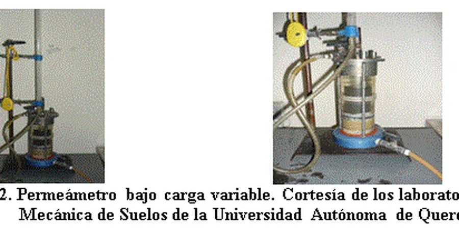
Constant Head Permeability
For clean sands and gravels. We use the ASTM D2434 method with a fixed hydraulic gradient. Tests run on compacted or undisturbed samples. Ideal for dewatering design and drainage layer specification.
Falling Head Permeability
For silts, clays, and glacial tills. We apply the ASTM D5856 method using a rigid-wall permeameter. Suitable for fine-grained soils where flow rates are low. Results used for seepage analysis and consolidation modeling.
Custom Permeability with Temperature Control
For permafrost-affected soils or projects requiring field-relevant conditions. We run tests at specified temperatures (e.g., 5 °C to 25 °C). Includes full data report with temperature correction curves.
Typical parameters
Q&A
What is the difference between falling head and constant head permeability tests?
Constant head is used for coarse-grained soils (sands, gravels) where flow is steady. Falling head is for fine-grained soils (silts, clays) where flow decreases over time. Both measure hydraulic conductivity, but the choice depends on soil type and expected k range.
How much does a laboratory permeability test cost in Anchorage?
The typical range for a single test is between US$410 and US$660. This covers sample preparation, conditioning, testing at two hydraulic gradients, and a full report. Bulk discounts apply for multiple samples from the same site.
Which standard applies to permeability testing in Alaska?
We follow ASTM D2434 for constant head and ASTM D5856 for falling head. Both are recognized by IBC and ASCE 7. For permafrost or frozen ground, we also reference ASTM D6035 for unsaturated hydraulic conductivity.
Can you test frozen or disturbed samples?
Yes. For frozen samples, we thaw them under controlled conditions to preserve structure. Disturbed samples are reconstituted to target density. We document any changes in the report. Results are valid for design when sample disturbance is minimal.