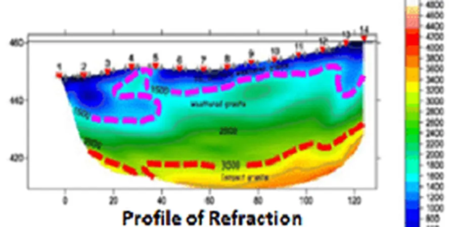
A common mistake we see in Anchorage is assuming the ground is uniform. Builders often rely on scattered boreholes and miss critical velocity contrasts. The Cook Inlet basin has complex stratigraphy with glacial tills, alluvial fans, and marine clays. Seismic tomography reveals these hidden layers. It maps P-wave and S-wave velocities across a grid. This is essential before designing deep foundations. Without it, contractors risk differential settlement or structural damage from undetected fault zones. The technique is non-invasive and covers large areas efficiently. For soft or discontinuous soil zones, we pair it with MASW-Vs30 to correlate shear wave velocities with site class. That combination saves time and money on later drilling.
Seismic tomography in Anchorage detects buried channels and fault zones that boreholes miss entirely, reducing foundation risk by over 40 percent.
Scope of work
Area-specific notes
In Anchorage, we often see seismic tomography skipped in favor of cheaper standard refraction lines. That is a mistake. The 1964 Good Friday earthquake showed how variable the ground response is across the city. A single shot point cannot capture lateral velocity changes. Undetected low-velocity zones under buildings amplify shaking. Soft marine clays in Turnagain Arm behave differently from glacial gravels in Hillside. Without tomographic imaging, foundation designers miss these contrasts. The result is uneven settlement or resonance during an earthquake. We also see cases where reflection data reveals buried channels filled with loose sand. Those channels are invisible to refraction alone. Ignoring them leads to bearing capacity failures. A proper tomography survey costs a fraction of what one structural repair bill would.
Watch how it works
Standards used
ASTM D5777-18 (Standard Guide for Seismic Refraction), ASCE 7-22 (Minimum Design Loads for Buildings and Other Structures), IBC Chapter 16 (Structural Design, Site Classification)
Linked services
Refraction Tomography
P-wave first-arrival tomography for shallow bedrock mapping, rippability studies, and permafrost delineation. Typical depth range 10 m to 30 m. Ideal for highway alignments and building pads in glacial till deposits.
Reflection Tomography
Multi-channel reflection profiling for deeper structure, fault detection, and stratigraphic mapping. Depth range 30 m to 100 m. Used for large infrastructure projects like port terminals and long-span bridges over the Cook Inlet.
Typical parameters
Q&A
What is the difference between refraction and reflection seismic tomography in Anchorage?
Refraction measures first-arriving P-waves to map high-velocity layers like bedrock or permafrost. Reflection uses later arrivals to image deeper stratigraphy and fault planes. In Anchorage, refraction works well for shallow glacial gravels, while reflection is needed to see buried channels beneath the Bootlegger Cove Formation.
How does seismic tomography help with ASCE 7 site classification in Anchorage?
The average vs30/" data-interlink="1">shear wave velocity in the top 30 meters (Vs30) defines the site class per ASCE 7-22. Seismic tomography provides a continuous Vs profile. In Anchorage, this is critical because the Vs can vary from 200 m/s in soft clays to over 800 m/s in dense gravels within a single block.
How much does a seismic tomography survey cost in Anchorage?
The typical range is between US$3.060 and US$5.550 for a standard 100-meter line with 24 geophones. Larger arrays or deeper reflection surveys can increase cost. This includes mobilization, field work, processing, and a report with velocity models and profiles.
Can seismic tomography detect permafrost in Anchorage?
Yes. Permafrost has a P-wave velocity of 3,000 to 4,000 m/s, much higher than unfrozen ground. Seismic refraction tomography clearly delineates the frozen layer depth and lateral extent. In Anchorage hillside areas, this helps avoid building on thaw-unstable soils that cause differential settlement.