Anchorage sits on a deep basin of glaciolacustrine deposits, alluvial fans, and marine silts. The 1964 Good Friday earthquake showed how loose saturated soils amplify motion and trigger lateral spreading. For any project here, understanding the natural resonance frequency of the ground is not optional. The HVSR microtremor survey (Nakamura method) measures the horizontal-to-vertical spectral ratio of ambient vibrations. It identifies the fundamental site frequency in minutes. This is critical when the structure's natural period matches the soil's period. A single station records 20–40 minutes of microtremors. The data separates body waves from surface waves. We cross-check results with response spectra analysis to validate the amplification curve. The method works in urban areas where active sources are impractical. In Anchorage, ambient noise from traffic and wind is actually a benefit. The HVSR microtremor survey captures that energy and turns it into a reliable profile.
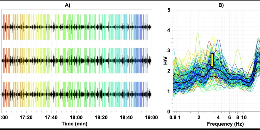
A single 30-minute HVSR recording can reveal whether a site will amplify seismic motion by a factor of two or more. That is a design-changing insight.
Scope of work
Area-specific notes
We deploy the seismometer directly on the ground in a shallow hole. In winter, we pre-thaw the surface with a portable heater. The sensor must be level and coupled to mineral soil, not snow or ice. A common mistake is placing it on frozen organic mat. That gives a false peak from the ice layer. We scrape down to mineral silt or gravel before recording. In downtown Anchorage, underground utilities generate 60 Hz noise. We apply a notch filter during processing. If the site is next to a highway or rail line, we extend recording to 40 minutes to capture a stable average. The biggest risk is misinterpreting a single peak as fundamental when it is actually a higher harmonic. We always check for consistency across three nearby stations. If peaks shift by more than 15%, we re-occupy the site. This method is solid, but it requires a technician who understands Anchorage's specific soil layering.
Watch how it works
Standards used
ASCE 7-22 – Minimum Design Loads and Associated Criteria for Buildings (Site Class), IBC 2021 – International Building Code (Seismic Design Categories), Nakamura, Y. (1989) – A Method for Dynamic Characteristics Estimation of Subsurface Using Microtremor on the Ground Surface
Linked services
Single-Station HVSR Screening
A rapid reconnaissance for preliminary site characterization. One to three stations per parcel. Output includes the H/V spectral ratio curve, peak frequency identification, and a site class recommendation per ASCE 7. Ideal for feasibility studies, pre-design assessments, and small residential lots in areas like Spenard or Midtown.
Multi-Station HVSR Array for Deep Basins
Designed for large commercial or infrastructure projects. Six to fifteen stations spaced 50–150 m apart. We generate a 2D resonance frequency map and overlay it on known subsurface profiles from the Alaska Division of Geological & Geophysical Surveys. This service is used on sites near the Knik Arm, Port of Anchorage, and along the Seward Highway corridor.
Typical parameters
Q&A
What is the difference between HVSR microtremor and a traditional seismic refraction survey?
HVSR is passive and requires no artificial energy source. It records ambient vibrations from wind, traffic, and microseisms. Seismic refraction uses an active hammer or explosive source. HVSR gives the natural resonance frequency of the soil column, not P-wave velocity. It is faster, cheaper, and works in noisy urban areas. However, it does not provide a velocity-depth profile on its own. For that, we combine HVSR with MASW.
How much does an HVSR microtremor survey cost in Anchorage?
The typical cost for a single-station HVSR survey in the Anchorage area ranges from US$1,680 to US$2,740. This includes field recording, data processing, and a report with H/V curves and site class. Multi-station arrays or projects requiring winter mobilization may add 15–25% due to heating and site access logistics.
Can HVSR be used on permafrost or frozen ground?
Yes, but with precautions. The sensor must be coupled to mineral soil, not ice or organic mat. In winter, we pre-thaw the surface layer. Frozen silt or gravel transmits vibration well, so the recording quality remains high. However, if the active layer is thicker than 1 m, the seasonal thaw may change the resonant frequency. We recommend surveying during the same season as planned construction, or repeating the survey after thaw.