Anchorage sits in a region where permafrost, glacial till, and seasonal thaw cycles create a uniquely challenging subsurface. The city's location near Cook Inlet means groundwater salinity can skew standard geophysical readings, so we calibrate our electrical resistivity arrays specifically for these conditions. Before any deep foundation design or slope assessment, running a vertical electrical sounding (VES) here helps us map the transition zone between frozen and unfrozen ground. We often pair this resistivity work with a [MASW survey](/masw-vs30/) to cross-check shear wave velocities against resistivity layering, especially on the Hillside where colluvium over bedrock is common.
Resistivity surveys in permafrost zones must distinguish ice-rich silt from thawed sand — the contrast can be 10:1 in ohm-m values.
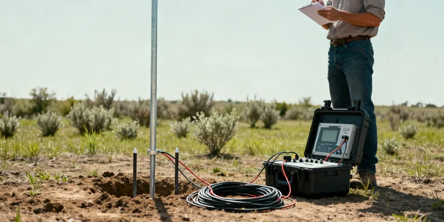
Scope of work
Area-specific notes
Anchorage experienced the 1964 Good Friday earthquake (M9.2), and the city sits on the subduction zone interface. One major risk during spring thaw is that resistivity readings in frozen silt (typically >1000 ohm-m) can drop below 50 ohm-m once the ice melts, completely changing the interpreted soil profile. If a geotechnical team relies on dry-season resistivity alone, they may underestimate liquefaction susceptibility in saturated sands along Ship Creek or Turnagain Arm. We always recommend running a parallel borehole with SPT to calibrate resistivity anomalies against actual soil behavior under cyclic loading.
Standards used
ASTM D6431-18 (Standard Guide for Using DC Resistivity), ASTM D6429-23 (Standard Guide for Selecting Geophysical Methods), IBC 2021 Section 1803 (Geotechnical Investigations)
Linked services
2D Electrical Resistivity Tomography
Multi-electrode profile along a survey line up to 400 m long. Ideal for mapping bedrock depth, fault zones, and permafrost extent in subdivisions or road corridors.
Vertical Electrical Sounding (VES)
Schlumberger array expanding from 1 to 100 m half-spacing. Used for deep groundwater exploration and characterizing the thaw bulb beneath existing foundations.
Resistivity Monitoring for Thaw Settlement
Repeated surveys over seasonal cycles to track permafrost degradation under buildings or pipelines. Data compared against thermistor strings for calibration.
Saline Intrusion Mapping
Focused surveys near Cook Inlet or tidal zones to delineate saltwater intrusion in shallow aquifers. Combined with water sampling for conductivity verification.
Typical parameters
Q&A
How deep can a VES survey reach in Anchorage's glacial till?
With a maximum AB/2 spacing of 200 m, we typically achieve reliable data down to 80–100 m in till. In areas where ice-rich silt is present, the resistivity contrast is high enough that we can resolve layers as thin as 2 m at 50 m depth.
What is the cost range for a resistivity survey in Anchorage?
A standard 2D resistivity profile with 48 electrodes costs between US$640 and US$1,000. This includes mobilization within the municipality, one day of field work, data processing, and a report with interpreted cross-sections.
Can resistivity distinguish frozen from unfrozen ground reliably?
Yes, frozen silt and sand typically show resistivities above 1,000 ohm-m, while the same material thawed drops below 100 ohm-m. The challenge is when saline groundwater is present — conductivity increases and the contrast narrows. We always cross-check with a borehole in those cases.
Do you need a permit to run resistivity surveys on public land in Anchorage?
For surveys on municipal property or along roads, we coordinate with the Anchorage Traffic Department and obtain a right-of-way permit. Private land requires written permission from the owner. Surveys inside the Chugach State Park boundary need a special use permit from the Alaska DNR.